


While potential plans have been designed, the future of a large section of undeveloped land in Platte City will largely depend on what the market can support during an undetermined development period.
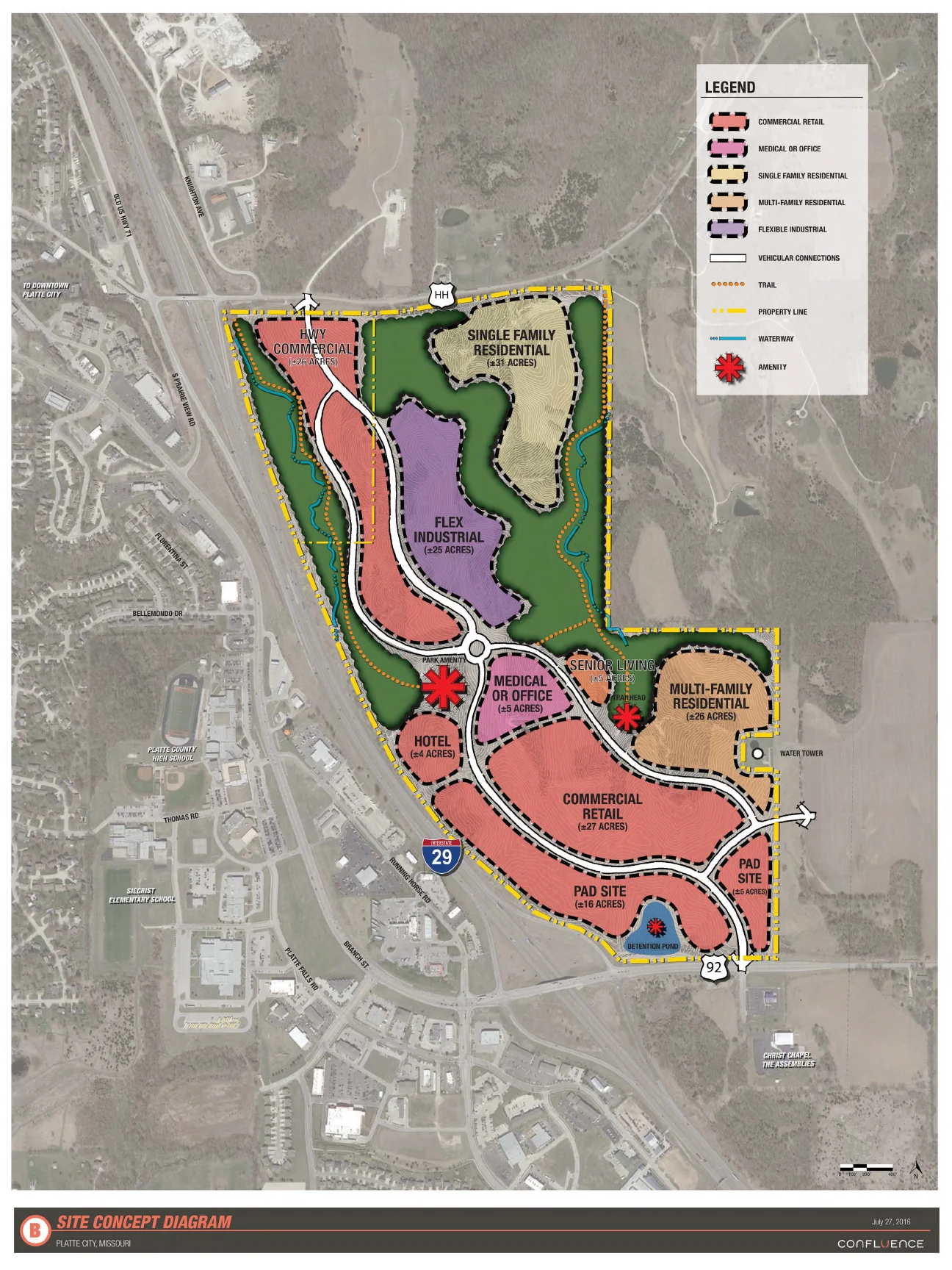
Last week, Confluence and RH Johnson held a pair of public meetings at the Platte City Civic Center to show citizens four proposals for about 200 acres of land located east of Interstate 29 and between HH Highway and Highway 92. The City of Platte City owns a small portion of land in the northwest corner, while private owners hold the remainder and largest swath.
The four designs showed examples of potential land usage, while the developer and designer continued to seek feedback from the public.

Officials want to use the input to help determine a final proposal that the city hopes to have done by the end of the year. However, the actual development will likely remain somewhat fluid with the market helping to determine usage.
Topography and infrastructure needs will help determine some of the plan. All four of the proposals can be viewed on page 7 of this week’s issue.
In all four of the plans presented, there were consistent usages in the northwest, northeast and southern portions of the land.

Submitted graphics
Confluence, a firm specializing in landscape architecture and urban design, provided the following conceptual plans for usage of about 200 acres of land in Platte City located east of Interstate 29 between HH Highway and 92 Highway. You can click on each for a more detailed view. The City of Platte City and private landowners are working in cooperation to seek development of the plot of land. A pair of public meetings were held Wednesday, July 27 at the Platte City Civic Center to show off the above renderings and to continue seeking feedback from the public. Development would likely occur in phases, and while the city will receive a final plan, what actually goes onto the land will be determined by the market moving forward.
Single family residential appears to be preferred in the northeast where challenging terrain appears optimal for unique housing lots. The amount varied by plan with one option showing close to 73 acres.
In the northwest, officials envision what they label as “highway commercial,” meaning destination retail sites. Examples included farm and ranch stores or tractor dealerships, places people know they want to visit when going out. Impulse stops don’t make sense there due to the location on HH, which requires a person traveling south to exit well ahead of the destination without being able to see the buildings and signage.
In the south looks to be the spot with more traditional retail would be preferred. The amount varied from plan-to-plan and included pad sites, which would be standalone stores or restaurants with surrounding parking lots.
The portion in the middle could include a combination of other options. These could include all or some of industrial/shipping, multi-family residential, hotel, churches, community center, office/medical buildings and senior housing.
The Platte City Planning and Zoning Commission would help guide any potential development, which is not slated to start at any determined date.
Confluence, a firm specializing in landscape architecture and urban design, hopes to provide a blueprint for this development, while RH Johnson — the city’s partner — hopes to help find developers interested in the site. The groups held public meetings this past winter and have continued to narrow down the plan.
The city already constructed a sewer line between the west side of I-29 and its land in the northwest corner of the undeveloped property. Platte City city administrator DJ Gehrt has often described the process of starting development east of I-29 like cracking an egg.
The city hopes the initial infrastructure investment starts development, although it would be up to a potential developer where that process starts.
All of the plans also include green space, leaving trees intact in spots near existing waterways. Confluence has also included ideas for undefined amenities and trail space in the more difficult to develop areas.
Roadway connections appear to be preferred in the far northwest and southeast corners.
Those are shown to diverge in the middle along the topography, and one plan even shows a potential second road running through the single family residential area and up to HH Highway.
The roadway connections are shown in white, while potential trails are denoted with a dotted orange line.
The east side development is part of the City of Platte City’s established priority to encourage economic development. That includes projects aimed at retaining current businesses, while also offering areas of growth, which should help increase a currently stagnant property tax base.
Estimates on full buildout for the 200 acres east of I-29 are right now set between 10 and 20 years.